The town of Squamish lies between Vancouver and Whistler on the Sea to Sky Highway and it is an outdoor lovers paradise. There is rock climbing, hiking, paddling, swimming, kitesurfing, snowshoeing, skiing, and so much more. There are also a plethora of outdoor outfitters if you need gear, lots of artisanal coffee, craft beer, and delicious food to have before or after your outdoor activity of choice.
Today I am going to be talking about the best hikes in and near Squamish. If you feel like driving a bit further south, you can find my guide to West Vancouver hikes here, and North Vancouver hikes here. You can find my guide to all of the hikes between Vancouver and Squamish such as Lions Bay here.
Hikes Near Squamish
Table of Contents
These hikes are organized in part by level of difficulty and in part by distance.
1. Alice Lake (and Four Lakes)
Distance: Up to 6km | Elevation Gain: Minimal | Difficulty: Easy
Alice Lake Provincial Park is just north of Squamish and is a great place to spend the day swimming, paddling, picnicking, as well as hiking! There are many trails that wander around the lake and through the forest. The land here is mostly flat so the trails are all pretty easy and normally snow-free year-round.
One of the best trails is called Four Lakes, and you guessed it, it takes you past four different lakes. Enjoy this serene walk in the woods. Be aware that this is a popular park so parking can fill up quickly on a sunny weekend.
2. Smoke Bluffs
Distance: Approx. 3km | Elevation Gain: Approx. 150m | Difficulty: Easy/Moderate
This trail takes you past some popular rock climbing spots but also gives you beautiful views of the mountains, ocean, and valley. This is a fairly easy hike that you can usually do year-round.
There are lots of trails in this area (shortly off the highway behind the Squamish Adventure Centre) so feel free to explore and lengthen/shorten the hike to your liking.
3. Browning Lake and Jurassic Ridge
Distance: 2.5km | Elevation Gain: 200m | Difficulty: Moderate
This trail is in Murrin Provincial Park which is just off the Sea to Sky Highway south of Squamish. This is a popular area for rock climbing but there is also a trail that takes you to a beautiful view of the Howe Sound. Do this trail on a clear dry day year-round.
Though this trail is short, still be prepared for some steep sections, including some rope-assisted scrambles. It is easy to make this adventure longer by exploring further trails in the park. The parking lot is on the smaller side so prepare for it to be full and busy on a sunny weekend.
4. Shannon Falls Pools
Distance: 2.5km | Elevation Gain: 250m | Difficulty: Moderate/Challenging

Shannon Falls is an iconic part of the Sea to Sky and Squamish area, it is a well known view and it is easy to pull off the highway, park, and walk straight up to the base of the falls to admire their intensity but there are some alternative views of the falls as well.
One alternative option is to hike up to the top of the falls where you will find a set of pools and a view of the ocean. The hike to get there is pretty short but it is steep and technical and there are several spots you will need the built-in ropes to assist you.
It is very slippery when wet so I would recommend going on a dry day, though still be sure to wear shoes with good grip, and probably don’t bring your dog on this one. You will find a similar view of the falls from above if you follow the Sea to Sky Summit Trail (listed below).
5. Crooked Falls
Distance: 5.5.km | Elevation Gain: 500m | Difficulty: Moderate

This trail leads you to massive gushing falls and on the way you will find a variety of terrain with stream crossings, a few small waterfalls, a view of the valley, and both flat and steep terrain, which makes for a fun and interesting hike.
This hike is best done between April and October as it can get icy in the winter making the rocks slippery and the steep parts very challenging. You can get very close to the waterfall but be sure to be cautious as it is easy to slip and fall.
6. Slhanay Peak
Distance: 6km | Elevation Gain: 650m | Difficulty: Moderate/Challenging
This trail gives you a great view of the Chief and a pretty good workout. It starts from the same area that the Chief hike starts but diverges and takes you up a neighboring slope.
The hike has some steep parts and some flat parts and plenty of rocks and roots to climb over. The rocks are slippery so I would recommend doing this hike on a dry day between April and October.
Be sure to download a trail map before you go because the turn-offs can be easy to miss. Also, be sure to take all of the little detours to the south side of the mountain (such as Tonys and Hanging Gardens) so you can get that beautiful view of the Chief.
7. Mount Crumpit
Distance: 5km | Elevation Gain: 300m | Difficulty: Moderate/Challenging
Much like Slhanay, this trail gives you views of the Chief, this time from the backside. The trail can usually be accessed year-round unless there has been low-level snowfall.
Be sure to download a map before you go because there are lots of intersecting trails and it can be easy to get turned around. Note that many of the trails in this area are popular for mountain biking so keep an eye out for bikers.
The trail definitely has some challenging parts with slick rocks and scrambles, so though the stats on this trail make it sound easy, it is not and will leave you sweating and having a great adventure.
8. The Stawamus Chief
Distance: Up to 6km | Elevation Gain: Up to 650m | Difficulty Moderate to Challenging

The Chief is one of the most iconic hikes in the area and lives up to its fame. Climbing this giant rock mountain you will find yourself climbing upwards steeply over stairs and roots, climbing ladders, and pulling yourself over steep sections with ropes. In the end, you will find beautiful views of the Howe Sound and the Garibaldi Mountains.
There are three different peaks you can go to on this trail, if you choose to just go to the first peak (which is as beautiful as the others) the trail will be a bit shorter overall.
This hike has the potential to be done year-round but be prepared to find ice on the trail and at the top in the winter which can be significantly dangerous on this trail due to the slick rockiness. Keep an eye on The Cheif webcam, recent weather reports, and recent trail reports to decide if it is safe to climb in the winter months.
9. Sea to Summit
Distance: Up to 16km | Elevation Gain: 900m | Difficulty: Challenging
This trail is an alternative way to get to the top of the Sea to Sky Gondola without actually taking (and paying for) the gondola ride. The trail starts at the same place as The Chief hike and veers off onto its own trail which takes you near the top of Shannon Falls and eventually to the top of the Sea to Sky Gondola where you will find a skywalk, a restaurant, and more trails to explore if you have the time and energy.
After you have taken in the sights you can turn around and walk back down the mountain or you can purchase a downloading-only ticket (reduced) to get back to the parking lot.
There is also a trail that goes directly beneath the gondola that is shorter but much more grueling and less scenic but will get you to the top a bit faster.
I would recommend doing this trail no earlier than April or May, though there is snowshoeing at the top of the gondola in the winter if you are keen on buying a round trip gondola ticket to access those trails between December and March.
10. Watersprite Lake
Distance: 20km | Elevation Gain: 800m | Difficulty: Moderate
This stunning blue lake surrounded by rocky peaks is stunning and the hike to get there is equally great. The hike is accessible as early as late May, though there will still be snow and ice on the lake. The hike is on a nice gradual slope the majority of the time with lots of varying flora and terrain and beautiful mountain views along the way.
At the lake there is a campsite and a small shelter for those wanting to make this a two day trip.
There is also an alternative winter snowshoe route but it can be prone to avalanches so only go if you are very experienced in snow-safety.
Please note that the road to the trailhead is VERY rough, do not attempt it without a solid 4WD vehicle, and definitely not if you have a low-clearance vehicle. Be prepared to spend an hour or more driving the forest road to get there.
11. Elfin Lakes+
Distance: 20km | Elevation Gain: 800m | Difficulty: Moderate

This is the perfect hike for those who are working on their endurance and want to start taking longer hikes but are not ready for massive amounts of elevation gain. The trail has a nice gradual elevation gain on a well-maintained trail for the first 5km until you hit Red Heather Hut (a warming hut to take a break in), after that the trail becomes a bit more rugged, but flatter, and you will be on a ridge where you can see mountain ranges most of the time.
When you arrive at the lakes you will find several small pools (each one has a specific purpose so be sure to read the sign before dipping your feet in or filling up your water bottle), and there will also be mountains all around you.
You will also find a nicely maintained campsite, a warming hut, and a shelter that has bunk beds and other facilities. This is an excellent place to stay overnight and the shelter is open in winter as well for the snowshoe or ski touring folks.
If you want to camp and explore further in the area you can add on the trail to Mamquam Lake, Opal Cone or the Gargoyles.
Please note that the trail is on an old dirt forest road so take your time getting there and if you intend to use these trail in the winter (snowshoe or skiing) the end of the road requires tire chains. If you are hiking in the summer I would recommend going between the end of June and September.
12. Garibaldi Lake+
Distance: 19km | Elevation Gain: 1000m | Difficulty: Moderate
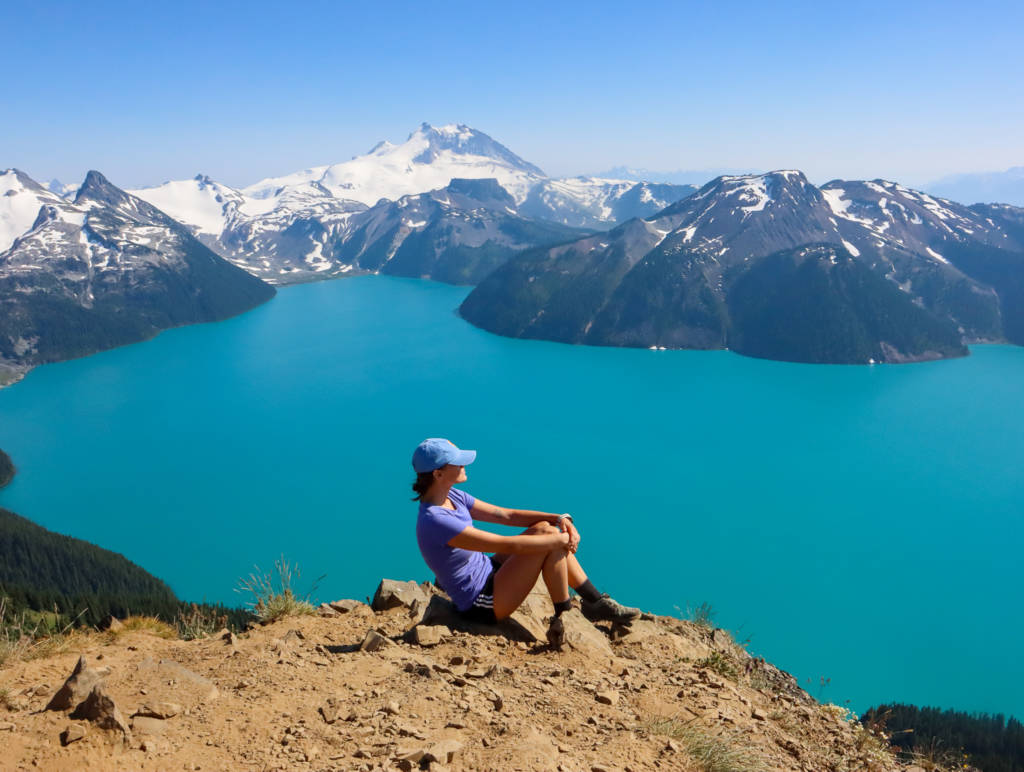
This is another of the most iconic hikes in the area which leads you to a stunning blue lake surrounded by mountains. The hike to get there is fairly gradual and just takes some perseverance to walk on a slope in the woods for a while, which makes it moderate instead of challenging.
At the lake, you will find one campsite and a second campsite at the nearby Taylor Meadows. This is a popular place to stop and camp before heading onto some of the nearby peaks such as Panorama Ridge, Black Tusk, and Mount Price.
All of these add ons are more challenging and add 10 to 14 km and about 600m of elevation gain to the trip. It is possible to do the entire hike to one of these peaks in one day but be prepared to be hiking all day long and go well prepared with plenty of food and water. If you only have time for one peak I would recommend Panorama Ridge though they are all incredible.
The hike to Garibaldi Lake is frequently snow-free as early as May and can be done as a snowshoe trail in the winter. I would recommend going to any of the further peaks only between July and September.
13. Brandywine Meadows or Brandywine Mountain
Distance: 11 to 16km | Elevation Gain: 800 to 1500m | Difficulty: Moderate or Challenging
Brandywine Falls are a must stop location on your way to Whistler, but there are also some great trails in this area such as Brandywine Meadows and Brandywine Mountain which starts on the other side of the highway to the falls and at the end of a forest service road.
The road needs a high clearance vehicle at the end to get to the trailhead, but you can park lower down on the road and add some distance to your hike if you have a small car.
The trail is on the more challenging side of moderate to the meadows where you can find beautiful wildflowers at their peak in August and September, and potentially the end of July as well. The best time to hike here is between July and September so you should see some flowers no matter what. The meadows have beautiful mountain views and campsites to spend the night if you like.
If you choose to go on to Brandywine Mountain the trail becomes more rugged and challenging and it is a slog to get to the top but you will be rewarded with beautiful views.
This is a great summer hike, but the bugs also quite like this area so definitely bring bug spray.
14. High Falls Creek
Distance: 8.5km | Elevation Gain: 550m | Difficulty: Challenging
This hike is quite the adventure with many rope-assisted climbs, large rocks, and stream crossings but you will have mountains and valley views along the way and this hike can frequently be done year-round (unless there has been heavy snowfall).
I would recommend going when it has been dry for a few days because it can get very slick on the rocks. I also would recommend leaving your dog at home for this one because of all of the rock faces you will have to climb. Also, be sure to download a map before you go because it can be very easy to lose the trail.
15. Petgill Lake and Viewpoint
Distance: 11km | Elevation Gain: 800m | Difficulty: Challenging
This trail starts at Murrin Park, then takes you across the highway for the hike uphill. The trail has varied terrain with some steep rocky parts but also has some peekaboo views along the way.
At the lake you can lounge for a bit but be sure to take the short detour trail on the south side of the lake to get to the lookout of Howe Sound, it is well worth the extra 10 to 20 minutes of walking.
There are some conflicting signs at the beginning of the trail so keep your map open and follow what it says. I would recommend doing this hike between May and October. Remember that the Murrin parking lot is on the smaller side so arrive early on a sunny weekend.
16. Helm Creek and Panorama Ridge
Distance: 30km | Elevation Gain: 1600m | Difficulty: Challenging
This trail is an alternative route to get to Panorama Ridge that overlooks Garibaldi Lake (or you can take a detour to any of the other peeks in the area as well).
This hike can be done as a two-day trip by camping at Helm Creek but can also be accomplished in one day. The slope is more gradual than taking the trail directly from Rubble Creek (Garibaldi Lake trailhead) so it can be done a bit faster.
The trail option is quieter and has all sorts of different terrain and views. It can be quite windy on the ridge so be prepared with warm clothing and only do this hike from July to October.
The trail starts at the end of Cheakamus forest service road so be prepared for a rough drive-in. This could also be accomplished as a point to point if you have two cars and want to finish at Rubble Creek.
Conclusion
Get out and explore the trails near Squamish, you will not be disappointed! Happy hiking!


Welcome to Alpine Feeling! My name is Talon, an outdoor enthusiast who has spent extensive time in the mountains of Vancouver, Washington State, and the Canadian Rocky Mountains.